These routes are not just for the younger, older or unsteadier among us … sometimes even the hardiest of fell runners craves a simple route with no map-reading or having to jump trip hazards. Offering a true escape from the day-to-day and an immersion into nature, and yet easy underfoot trails without map reading. Although delightful in full sunshine, they are also handy after heavy rain, as they avoid boggy patches! Many would be fine for small children on bikes or in off-road buggies. We have provided Ordnance Survey map grid references and What3Words app locations to get you started, and navigation is easy. If you’d like these emailed to your inbox for easy reference, complete with links to the routes on OS Maps, Komoot and AllTrails, click here.
1. Forestry track nestled between Helvellyn and Thirlmere

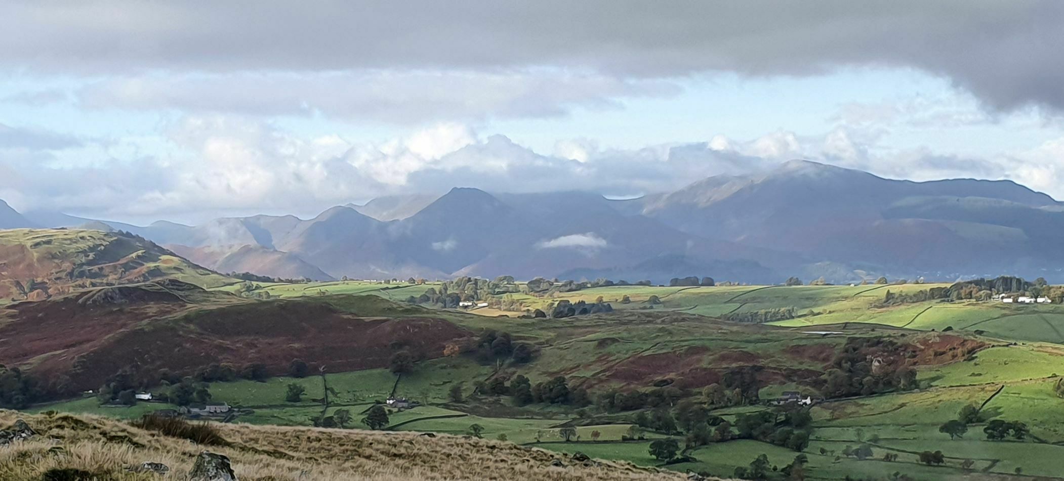
Being such a short and easy drive from Fornside, this wonderful all-weather track is a regular walk, run and cycle destination for us. Park either in Swirls car park or across the A591 where there is often an ice cream van (there is an underpass to avoid crossing the road). The track starts at the gate immediately to the left of the car park entrance as you look towards the road and goes south for some 4.7km. Some undulation is to be expected, as are wonderful views of Thirlmere. You may well see deer and red squirrels as you walk underneath Helvellyn Screes and toward the dramatic Steel Fell at the southern end of Thirlmere. This is an out-and-back route, so you could always shorten it, or, if you prefer a nice round 10K, then at the southerly end follow the track as it curves tightly right and downhill, through some huge gates and onwards; the 5km point is just a few metres short of where the track meets the road). On your return you will spot Raven Crag, overlooking the valley from the north and behind which the remains of a defensive fort stand, dating from 500AD. If anyone in your party can manage a short meander around steeper narrower paths, send them to explore the route around The Swirls (about 1km from the car park; there is a footpath sign), as there is a red squirrel hide, if you haven’t already seen plenty at Fornside, and a surprise vista looking north towards Castle Rock and St.John’s-in-the-Vale. This treat is best saved for the return journey, as the explorers can drop back down from the east side of The Swirls and re-join the party back in the car park.
Thirlmere was originally two smaller lakes in this valley, where there were once Bronze age and later Norse settlements, and up until the late 19th Century, the dwellings and pastures of various sheep farms. The two lakes were joined by a boggy area which, as it would flood regularly, was crossed by the two ‘Celtic Bridges’. There was controversy about the flooding of the valley, which has benefitted the citizens and industries of Manchester for nearly 130 years. The Institute of Engineering published this 6 minute film on the engineering feat of its 96 miles of gravity-fed aqueduct. Nowadays, Thirlmere supplies Keswick with water and it will soon also provide water to West Cumbria, courtesy of another controversial engineering project. (Sources for this paragraph: Wikipedia; Wythburn Church and the Valley of Thirlmere, by Geoffrey Darrall; the ICE and hidden-manchester)
Total distance: anything up to 10km / 6.2miles
OS Explorer Map OL5 grid refences, and what3words app locations:
Swirls Car Park start gate is here: GR 316168 W3W proves.teaches.breathing, follow the track south to its end at GR 326125 W3W helm.sleeper.nametag
The Ice Cream Van car park is at GR315171 W3W hungry.cries.cover
2. Force Crag Mine Track

Despite being less than 3.5km long, this trail plunges you deeply into the fells. As you follow it gently uphill, you’ll look down on the delightfully meandering Coledale Beck, nestled below Causey and Grisedale Pikes. Before long, the imposing face of Force Crag and some impressive waterfalls will be visible, leading you to your destination. Force Crag, now a National Trust site and museum but worked for 200 years for lead, then barites and zinc, until as recently as 1990. For more information about when the mine is open to visitors, see the National Trust webpage. Even if its closed, the scenery is wonderful and there are some interesting and informative boards to read on the site. It’s about an hour’s walk each way.
Total distance: about 7km
OS Explorer Map OL4 and what3words app locations:
Drop off anyone who would prefer to avoid walking up the road at the start of the track here: GR 227238 W3W approvals.section.encourage
… then park at Braithwaite Methodist Church GR 229236 W3W erupts.haystack.darling
… or at weekends park in Braithwaite School GR 232237 W3W calendars.bumping.covenants
From the start, the track takes you in a south-westerly direction to Force Crag Mine Mine GR 199217 W3W condense.clinic.enabling
3. Thirlmere Dam crossing

Although half of this route is open to traffic, we’ve included it because there are very few vehicles (mainly farm machinery) and the dam offers a very easy walk with lovely views. If you were interested in the paragraph about the history of Thirlmere on the first walk, this is a ‘must’. Carefully cross the A591 from the parking spot and walk past High Bridge End farm and its campsite. If you watched ‘The A Word’, look north to Smaithwaite where scenes including Paul’s gastropub ‘The Fellside’ were filmed. Beyond this you’ll see the peaks of Skiddaw & Little Man. Stay on the road, which is blocked to traffic after access to the water works. After a rock cutting you will find yourself on the majestically winding dam, which was built by the Victorians to allow the water levels to rise up to 17m to provide water to Manchester (see walk 1 above for more on this). The views across the water towards Helvellyn are wonderful. The walk is only a kilometre each way but could of course be extended along the road past the yellow barrier – just watch out for the odd vehicle.
Total distance: 2km
OS Explorer Map OL5 and what3words app locations:
Park at the layby GR 316196 W3W spirits.snug.misty
Cross the main road and follow the country road south-west along to the dam
The yellow gate is at GR 307189 W3W chapters.husky.warned
4. One of ‘The Terraces’

Look north from Fornside and you will see a valley between the slopes of Lonscale Fell and Blencathra; herein flows the Glenderraterra Beck. The paths perched on the sides of this dramatic valley are locally referred to as ‘the terraces’, and the eastern one is a lovely wide track following a gentle gradient for 2.5km, allowing you to enjoy the thrilling scenery without any tripping hazards or the need to navigate. Simply park in the layby just past the Blencathra Centre and walk on up! Expect a ford next to a waterfall after about 1.5km; rarely does it exceed ankle depth but do wear waterproof boots. The track becomes a little bumpier shortly before the two wooden bridges where you turn around and retrace your steps … perhaps having eaten your picnic on one of the many grassy spots here, with dramatic scenery to entertain you. As you return the hills gradually reopen, offering splendid views over St. John’s-in-the-Vale, the Riggs, Walla Crag, Derwentwater and the fells beyond.
Extending the walk would take you onto some rather trickier paths, but these are worth a mention: if you were to venture beyond the bridges and gate, onto the narrow rocky footpath, you could loop left around the western side of the Glenderraterra, where the other terrace skirts Lonscale Fell, and possibly take in Latrigg before returning via Wescoe. Those who go rightish into the Northern Fells will soon reach Skiddaw Bunkhouse, the highest Youth Hostel in England.
Total distance: 5km
OS Explorer Map OL5 and what3words app locations:
Park at the layby car park just past the Blencathra Centre GR 302257 W3W dolly.tolls.velocity
Walk west for a short while and then the track goes northwards. The first bridge is at OS grid ref. 297278 W3W resolves.savers.torches
5. Threlkeld to Keswick disused railway line path

The former railway line gracefully curves through the dramatic scenery of the gorge, overlooking the rapids of the twisting River Greta as well as immersing you in delightful woodlands. The trail is marked with many informative signs about its history. For those with an engineering interest, there are new and refurbished bridges, tunnels, rock cuttings, and remnants of mechanical signal infrastructure can be spotted alongside the track. This route, a vital off-road connection between Threlkeld village and Keswick town, was reopened with significant improvements, five years after Storm Desmond made much of the route unusable. A huge fundraising effort was required for the substantial work along 5km of trail, and the resulting new path is not only tarmacked, but has a series of picnic benches, perches, and other interesting stopping points.
At the Keswick end you may wish to visit the Keswick Museum and Art Gallery, or the café and playground in adjacent Fitz Park. Back in Threlkeld, we can recommend either the Community Coffee Shop for lunches, cakes and hot drinks, not to mention superb views towards Clough Head, or The Horse and Farrier for a hearty pub lunch. There is often an ice-cream van halfway along the ‘line’.
To make this a circular, and slightly hillier, route you could return via Wescoe and Bundleholme; overlooking the dramatic gorge, this route is also tarmacked, but do expect the odd vehicle on the country roads.
The Lake District National Park has published information on the route here and you can read more in this Sustrans article.
Total distance: 10km
OS Explorer Maps OL4 and OL5 what3words app locations:
Either park at the Leisure Centre in Keswick GR 270238. longingly.scouting.resides – this is at the start end of the ‘line’, or look for a space in Threlkeld Village. Alternatively, park at the Quarry GR320245 finders.stress.condense and follow another stretch of disused railway (rough gravel surface) to join the main route.
6. Derwentwater’s near shores

This walk along the shores of Derwentwater offers ever-changing vistas across the lake and is easy underfoot. Walk down Lake Road, past the Theatre by the Lake and the small National Trust shop. Enjoy watching a little boating activity from the jetties before you continue south past the boat houses and on to Friar’s Crag. Stop to enjoy the views (there is a bench) before turning backwards and slightly right (east), to descend to the waterline. This is a super spot for skimming stones or for watching geese that might be nesting on Lord’s Island. Past the stony beach you will reach some gates that lead onto a boardwalk. This was completed in 2020 to protect wildlife through the delicate ‘Ings’ woodlands and handily keeps your feet dry even in wet conditions! At the end of the boardwalk turn right along the track to a cattlegrid with a gated footpath. Go through and follow the path around the field; after another gate the path swings round to Calfclose Bay where you can visit the Hundred Year Stone (see photo), carved out of a boulder of volcanic rock to commemorate the centenary of the National Trust. If this has whetted your appetite to see more of the Borrowdale valley, why not hop on a Keswick Launch and cruise the lake?
Total distance: 5km
OS Explorer Map OL5 and what3words app locations:
Lake Road car park is at GR 265229 W3W crusaders.clutches.enabling
Walk south to the lake shore and follow the marked parth.
Calfclose Bay is at GR 269215 W3W trick.rhino.kick
A guide to the full ten-mile route around Derwentwater can be found here.
7. White Moss walks – Rydal Water and Grasmere

Lovely all year round, but especially in Spring when the side of Loughrigg Fell is blanketed in bluebells, and in Summer if any of your party fancy wild swimming? The shallow waters can be invitingly mild. As this is a short walk you could combine the visit with a stop at Wordworth’s Dove Cottage or The Grasmere Gingerbread Shop.
Park at White Moss car park and walk out the back of it, south-west-wards, along a lovely track with lots of interest including the river Rothay, a fjord if any of you find this more fun than a boring old footbridge, and large rocks along the shore of Rydal Water. After a while you will come to a snaking metal bridge. Here you can choose from two out and back walks. There are plenty of rough paths nearby if you want to make it a figure of eight or a loop, but you’ll have to go ‘out-and-back’ to use the smooth wide ‘easy-underfoot’ paths.
Cross the bridge and stick to the well-tended path rising through the woods, after a gap in a dry-stone wall turn left and follow the shores of Rydal Water, as in the photograph above. Once the path comes to a gate, about 1km after the woods, turn around and come back. Adventurous types might want to climb up to the famous Rydal Cave from here and meet you later on. When you’ve re-crossed the snaking bridge, it’s well worth the short walk left through Penny Rock Wood and over a wooden footbridge to the shore of Grasmere, where there is a lovely beach for paddling or wild swimming. This is a dreamy, tranquil spot, with enchanting views across Grasmere. We love the extraordinary geography that allows you to see from here, on a clear day, through the pass of Dunmail Raise, the valley of Thirlmere, and St. John’s-in-the-Vale … all the way to the familiar shape of Lonscale Fell!
Total distance: 5km if you do both ‘branches’
OS Explorer Map OL7 and what3words app locations:
Park White Moss Car Park grid ref 351065, W3W innovator.neater.villager
The snaking metal bridge is at grid ref 348064 W3W bonkers.locate.cowering
End of Rydal Water’s easy path GR 359060 W3W signified.punchy.champions
Beach on Grasmere GR 344059 W3W thirsty.daffodils.owes
8. Bowscale Tarn

This is a simple out and back walk with a well-hidden gem; Bowscale Tarn is only visible when you are right upon it. The track to achieve this delightful reward is probably too rough even for off-road buggies, but it is fairly short, easy to follow and follows a charming valley (see photo in blog header). There is one possible ford, but it is usually very shallow. Just before you round the hillock that hides the tarn, the gravel path becomes a grassy track. You can walk around much of the tarn to find your perfect picnic (or wild swimming) spot.
Total distance: less than 6km
OS Landranger map 90 Grid References and what3words app locations:
Park in one of the laybys before or after the few houses at Bowscale, Grid Ref 359317 W3W assets.workforce.tortoises. Walk from the point west towards a gate and follow this track up the side of Bowscale Fell, overlooking the River Caldew, until you round a hillock to reach Bowscale Tarn at grid ref 336315 W3W driftwood.select.opposing
9. The Old Coach Road
 We debated whether or not to include this route. We just had to! This is a fabulous track, if you can manage one 500m long section of steeper bumpier underfoot conditions; most of its length is, however, gravel or stones on manageable gradients. At five miles (8km) end to end it is an easily navigable yet properly ‘away from it all’ middle-distance run or walk. The route rounds Clough Head and crosses Threlkeld and Matterdale Commons, hugging the steeper slopes to the south all the way. You will see fell ponies, sheep and perhaps a farmer with his sheepdog, maybe even police officers completing their off-road 4×4 training, and of course you’ll be surrounded by views of Blencathra, past Keswick towards Whinlatter, Threlkeld Common and Great and Little Mell Fells. It can be quite exposed on windy days, so do wear or take appropriate clothing.
We have been unable to find out much about the history of The Old Coach Road, but being elevated, it would have certainly been a useful route to avoid too many boggy areas and river crossings when transporting people and goods between east and west. The ‘turtle and chicken’ website shows maps that include this road from the late 18th Century. At the St. John’s-in-the-Vale end you will see parts of Threlkeld Quarry, opened in the late 19th Century to supply ballast for railways and for the Thirlmere waterworks project, and later sold granite slabs. The Threlkeld Mining Museum & Narrow Gauge Railway is now located here, do check their website for opening days.
Total distance: 10 miles / 16km
OS Explorer Map OL7 and what3words app locations:
Park at GR 316231 W3W arriving.coasters.dished; this is the start of the track.
Go eastwards, through the large wooden gate, and you’re off!
The gate to the road at the far end is at GR380291 W3W soups.waltz.parked